VIDEO: Out with the heat and humidity–in with sunshine and cooler temps on Sunday!

Saturday night storms sweep out our heat and humidity
read more

VIDEO: Out with the heat and humidity–in with sunshine and cooler temps on Sunday!

The National Weather Service says an approaching cold front will bring the chance for strong to severe thunderstorms this afternoon/evening, capable of producing large hail and damaging winds. Severe threat is best north and west of I-95

The National Weather Service says we could see some breaks in clouds this afternoon, which could allow for some thunderstorms to develop. A few of these could become severe, with isolated damaging winds gusts being the main threat.
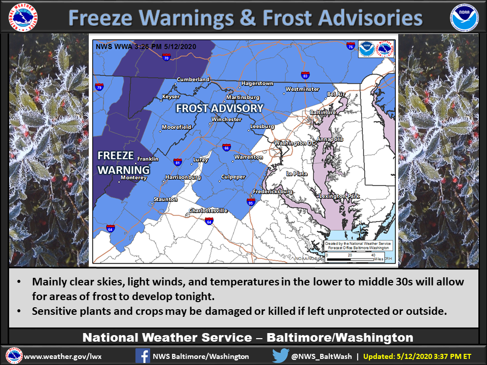
PHOTO: We could see frost early morning…

The National Weather Service says next weekend we could see temperatures in the mid-80’s

It will feel more like March than May this weekend. Freeze potential is concentrated in areas west of DC tonight thanks to a gusty wind, but may be more widespread Saturday night as light winds, clear skies and dry air allow temps to plummet.

The National Weather Service says we’ll see rain today. Most of it comes tonight

The National Weather Service says a cold front will be crossing the area today.

A Frost Advisory has been issued Saturday night/Sunday morning. Lows are expected to reach 33-36 degrees. Frost could kill sensitive outdoor vegetation if left uncovered.

PHOTO: Freeze Warning is in effect from midnight to 9am for most of the region. Take steps now to protect sensitive plants from the cold.

The National Weather Service says the High Wind Warning has been expanded to include south-central MD. Sustained winds of 20-30 mph, with gusts up to 60 mph expected. The High Wind Warning will be in effect from 6 AM until 6 PM on Monday. Included: King George,...

The National Weather Service says there is potential for a significant severe weather outbreak throughout the day on Monday.

Wind advisory today for areas north and west of Fredericksburg. Fires a concern today because of low humidity.

The Weather Channel says warmer than average temps are triggering early flower blooming and pollen!

The National Weather Service says low humidity and gusty winds will result in an enhanced risk of rapid fires today. Use extreme caution if you will be doing anything involving fire or flammable materials today

We begin a new month a little warmer today

The Weather Channel says big changes have been made to the March temperature outlook due to an unexpected pattern change. Previously, most of the Lower 48 was expected to experience a warm start to spring.

The National Weather Service says sunny skies today, but it will be brisk with wind chill values in the middle to upper 30s during the warmest part of the day.

VDOT creating brine lines on the Northern Neck. VDOT says those white lines will prevent snow from sticking to the pavement. Crews are pre-treating roads there and Middle Peninsula area with the chance of snow Thursday afternoon.

The Weather Channel predicts mild weather to continue
Today’s News Sponsored by:


